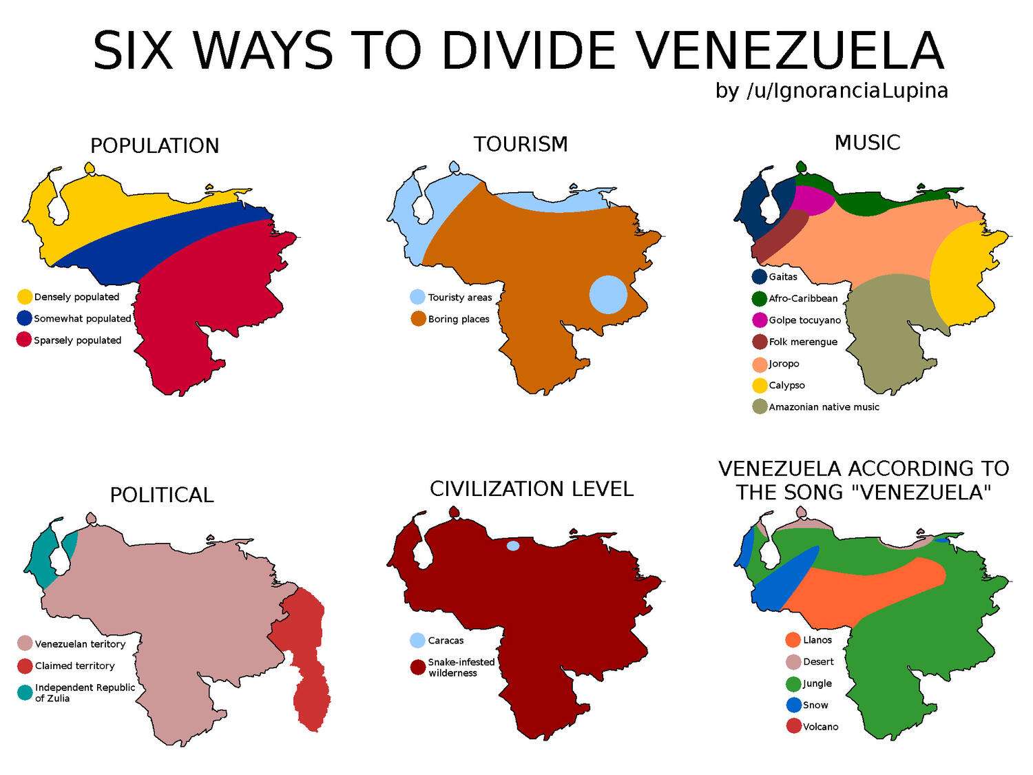
Six ways to divide Venezuela
IgnoranciaLupina:
Some background for the maps, especially for non-Venezuelans:
- Population:
There are roughly three zones in Venezuela: the densely-populated Costa-Montaña, which holds three quarters of the people in the country despite being roughly 20% of its land area.
The Central Llanos region, which is roughly 30% of the land but holds around one fifth of the population.
And the lands south of the Orinoco; the Guayana region, which is roughly half of the country's territory, but only holds 5% of its people.
- Tourism:
While I'd argue that the entire country is beautiful and fascinating for tourists, the vast majority of people prefer the major historical cities, the beaches, and the Gran Sabana region in the Southeast, what with its flattop mountains and half-mile tall waterfalls.
- Music:
"Gaitas" are both a regional folk musical style of Zulia state and the official Christmas music for the entirety of Venezuela.
Most of the coastline and inner mountains are heavily influenced by Afro-Caribbean music, especially drums. There is a lot of variety here (coast, mountains, cities) but they mostly, roughly, correspond to this family.
In the Northwest, there is a very particular style of music that's essentially a fusion of many other styles called "Golpe Tocuyano", centered around Barquisimeto, and it's distinct enough to warrant its own spot on the map.
Around the Andes mountains, there is a style of folk merengue, affectionately called by some as "Venezuelan hillbilly."
"Joropo" is the official soundtrack of the country. Originating in the huge sabanas, or plains, shared by Venezuela and Colombia, this style reflects the rural life of the Apure cowboys, and many other local styles.
Thanks to the gold mining industry, the population south of the Orinoco boomed in certain lucrative towns. One of them, El Callao, brought a lot of Caribbean immigrants who brought their Calypso tunes with them, and are now an integral part of the region, and of Venezuela's culture.
South of the Orinoco, there are many indigenous tribes, and their culture has been preserved thanks to public efforts and their native isolation. Some of their music is still dominating certain areas.
- Political:
Who owns this land? Most of Venezuelan land is rightfully recognized as part of Venezuela. A decent chuck of territory currently administered by Guyana is also claimed by Venezuela, and you will not see a map of Venezuela without Guyana Esequeiba marked with diagonal lines representing a Claimed Territory.
Also, Zulia State is the Texas of Venezuela. Oppressive heat, lots of cows, lots of wealth, lots of oil, all in a coastal, border state with its own culture and independence movements. Affectionately called the "Independent Republic of Zulia" by many.
- Civilization level:
There is a saying that goes "Caracas es Caracas, y lo demás es monte y culebra" (Caracas is Caracas; everything else is snake-infested wilderness). Here it is represented on a map.
- Venezuela according to the song "Venezuela":
There is a popular song in Venezuela that praises the beauty of the land and country, accurately called "Venezuela." It describes the "Desert, Jungle, Snow and Volcano" of the country, which I tried to map as accurately as possible, as well as the Llanos, or plains. Do note that there are no active volcanoes in the country, so who knows why's that even there.
Collection: divided - Tags: countries-divided, stereotypes, venezuela - Source: reddit.com