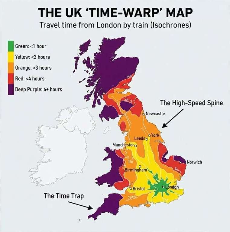
Travel time from London by train
author: the_uk_blend/instagram, added on: 2026-03-28
the_uk_blend:
Distance is an illusion. 🇬🇧⏱️
We usually look at maps and think in miles. But in the UK, time is the only metric that matters.
At The UK Blend, we created an Isochrone Map (from the Greek iso meaning 'same' and chronos meaning 'time'). This map doesn't show you how far away places are geographically; it shows you how long it takes to get there from London by rail.
The Data Breakdown:
🚄 The "Speed Fingers" (Vertical Corridors):
Notice the long bands of green and yellow stretching straight up the country? These are the East Coast and West Coast Main Lines.
Because of high-speed rail, you can physically be in York (200 miles away) faster than you can get to parts of Suffolk (80 miles away). The North is "closer" than the East.
🐌 The "Time Traps" (The Slow Zones):
Look at the purple and dark red zones in Cornwall, West Wales, and rural East Anglia.
These areas suffer from the "last mile" problem. Once you leave the main lines, travel time explodes. Geographically, they are on the same island. Chronologically? They might as well be in a different time zone.
The Trend:
The map reveals a "Two-Speed UK." We are a nation connected by rapid vertical spines, but disconnected in the rural margins.
Collection: isochrone-maps - Tags: london, travel-times, uk - Source: instagram.com